As Los Angeles prepares to host the 2028 Summer Olympics, City leaders are talking about a car-free (or transit-first) experience, drawing lessons from Paris, who just held the 2024 Olympics. Planned and executed carefully, these can be transformational events where a focus on inclusive transportation and environmental goals take center stage.
As average temperatures in many US cities continue to climb and debilitating heat events become more frequent, the importance of green spaces and shade in urban environments has become increasingly evident. National Heatstroke Prevention Day, observed earlier this month on May 1st, serves as a crucial reminder of the risks posed by excessive heat, particularly in densely populated cities like Los Angeles. To help mitigate these effects, one of the rays of hope we’d like to draw attention to is urban trees and shade.
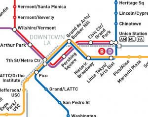
DCR has collaborated with LA Metro over the past few months to re-design and update the majority of its customer-facing maps, triggered by Regional Connector, a significant new enhancement to the Metro Rail network. The Regional Connector is a nearly 2 mile long underground rail project that adds three new stations to the Metro network and increases the rail connections between Union Station and 7th Street/Metro Center, the two Downtown LA transit hubs. This creates better opportunities for travelers, reducing transfers in Downtown LA and shortening journey times through the middle of LA.
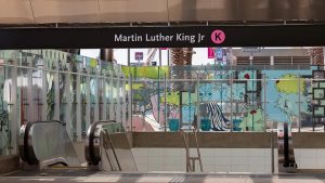
DCR has been busy working on a range of maps for the opening of the new LA Metro K Line. This involved creating new station maps as well as updating many existing maps showing the new station areas and transit system connections. Take a virtual ride along the entire line, which opened on Friday, October 7 2022. The need for the K Line was first recognized in 1967 – but there was a lack of funding at the time. When the Measure R sales tax was passed by LA County voters, funding was finally secured. Since then, hundreds of people have spent countless hours to make the K Line a reality.
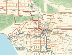
Every year ESRI collects a wide range of mapping products made by users all over the world and displays them in an online map gallery together with a printed book. This year, our redesign of LA Metro's Bus & Rail System Overview Map is showcased in the ESRI Map Gallery and printed book (Volume 37).
To see our map alongside many other interesting mapping projects in the gallery, use this link!