

Designing streets for people
Creating safe, comfortable, and connected spaces
When we think about great streets, it’s not just about space for cars—it’s about how people move, gather, and connect with their communities. Streets are public spaces, and when thoughtfully designed they are safe, comfortable, and inclusive for everyone—whether you walk, bike, roll, are using public transit, or driving. There lies a balance at the heart of people-centered design: mobility, accessibility, design language, canopy, ambiance and safety working in harmony with the urban environment.

At DCR Design we are dedicated to promoting safe mobility. Our mission is to enhance safe and sustainable mobility through creative mapping, intuitive signage, and equitable infrastructure planning. Georgia Crowley, one of our senior graphic designers, created the above diagram and we will walk you through how her layered design and how smart tools come together to support more livable streets:
1. Pedestrian zone
Sidewalks, storefronts, resting points, safety, comfort, accessibility
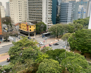
Sidewalks are our primary community connectors. Wide, accessible walkways support movement for people of all ages and abilities, while frontage zones—the spaces adjacent to buildings—bring life to the street through storefronts, seating, signage, and public art. These spaces invite people to linger, socialize, or simply enjoy their surroundings. They can also help identify key routes and highlight safe, intuitive pathways for pedestrians.
2. Landscape & furnishing zones:
Plant life, tree shade canopy, traffic buffer, street amenities, ambiance, comfort, safety
Between the sidewalk and the street lies a multifunctional zone that enhances safety and comfort. This area is often home to benches, light posts, transit shelters, bike racks, rain gardens, and crucially, trees. Urban canopy coverage is essential, providing cooling shade, reducing glare, improving air quality, and enhancing comfort for people on foot or moving on wheels. In hotter climates, this shade can make the difference between walking and opting out of active transportation altogether. A healthy, robust tree canopy also supports stormwater management, reduces heat island effects, and adds visual appeal. It is important to identify where more canopy is needed – especially in heat-vulnerable neighborhoods – for the environment, for communities and especially for the unhoused. Find out more about this in one of our previous blogs.
3. Curbside Management: flex zone
Parking & loading, business access, traffic buffer, pop ups, functionality, safety
Curbside space doesn’t just mean car parking. It’s a flexible zone that can serve many purposes throughout the day—from loading and deliveries to rideshare zones, outdoor dining, or pop-up events. These dynamic uses also act as buffers between fast-moving vehicle traffic and pedestrians. We can help plan and manage these zones more efficiently—reducing conflict points, slowing vehicle traffic, and maintaining curbside access while promoting safety.
4. Vehicle travel zone:
Sized for safety, reduced speed
Vehicle lanes should be designed for safety—not speed. Overly-wide roads lanes can encourage faster driving and increase crash risk. The Urban Street Design Guide, NACTO notes: “Narrower lane widths have been shown to reduce vehicle speeds without impacting traffic flow, leading to improved safety outcomes for all road users” suggesting a sharper focus from drivers in right-size lanes. Right-sizing lanes helps naturally calm traffic while creating space for other critical uses, such as bike lanes or larger pedestrian zones. It is crucial to identify and implement opportunities to reduce speeds and improve infrastructure design aligned with Vision Zero.
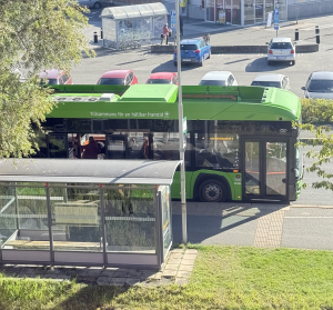
5. Bus only zone
Rapid bus service frequency, fast travel time, decrease congestion
Bus-only lanes are a critical piece of high-functioning transit corridors. By giving buses a dedicated right-of-way, delays caused by heavy traffic are reduced, service reliability is increased, and travel times are shortened—especially during peak travel hours. Bus lanes support higher-frequency service, which in turn makes transit a more viable and attractive option. Bus zones should include clearly marked loading and unloading points, accessible and comfortable shelters, and real-time signage to improve the rider experience. Prioritizing transit in street design not only benefits those who ride—it also reduces congestion for all road users by moving more people with fewer vehicles.
6. Bike zone
Protection, accessibility, connection to larger network, safety, comfort
Complete streets make room for bikes, too. Clear, well-marked, and protected bike lanes enhance safety, reduce conflicts with both cars and pedestrians, and encourage more people to consider cycling as a practical option. Separated, buffered paths, or a raised cycle track, improves equity and mobility—especially when supported by clear signage and wayfinding.
Our mapping and wayfinding tools highlight safe bike routes, intersections, and infrastructure gaps to support the full range of bike riders.


Every layer matters: streets as systems
Street design isn’t just about mobility—it’s about creating vibrant, equitable public spaces where people want to spend time. The interplay between sidewalks, tree canopy, bike lanes, flex zones, and traffic-calming measures shapes the daily experience of public life. Thoughtful design also supports social interaction, community health, local business vitality, and—most critically—safety.
Designing for a changing climate:
Why shade and equity matter
As average temperatures climb and extreme heat events become more frequent, the importance of urban shade and greenspace has never been greater. Yet, research shows that shade and tree canopy are not distributed equitably. USC spatial scientist John Wilson’s work underscores how tree-poor neighborhoods—often lower-income areas—face higher heat exposure and limited access to transportation options that might connect them to cooler places like the coast or mountains.
This issue is not just environmental—it’s a matter of health equity and transportation justice. Our tools help communities identify and address these gaps, advocating for trees, transit, and trails in the areas that need them most. Read more about this in our previous blog.
The power of mapping safer streets
Designing streets for people means looking at every layer—from sidewalks to signage, tree canopy to curbspace—and weaving them together with intention. Our work aims to improve cities, agencies, and communities with tools to visualize, plan, and create safer, more connected streets.
By combining intuitive mapping with inclusive design, we don’t just improve infrastructure—we communicate how people can better move, live, and thrive in their communities.
Let’s keep building streets for people—one sidewalk, tree, and bike lane at a time.

Want to work with us? Feeling inspired?
Contact us at info@dcrdesign.net or checkout our social medias: LinkedIn, X and Instagram
For more information visit: Vision Zero